
Have you ever swerved suddenly to avoid a pothole or felt your car jolt as you inadvertently drove over a deep crack in the pavement? These momentary disruptions are more than just inconveniences – they represent serious safety hazards that contribute to accidents and vehicle damage every day. Road pavement defects have become a significant factor in traffic accidents worldwide, prompting countries and federal states to invest more resources in analyzing and maintaining civil infrastructure.
Currently, road inspection relies heavily on specialized teams of inspectors and engineers who manually examine road surfaces. These professionals walk or drive along roads, meticulously documenting pavement distresses and assessing their severity. While these methods are time-consuming, subjective (depending on the inspector’s experience), and often cannot keep pace with the rapid deterioration of busy roadways.
Road safety is a pressing concern that affects all of us, whether we’re daily commuters, occasional drivers, or pedestrians navigating our urban environments. Every day, countless vehicles travel over roads that may harbor hidden dangers – cracks, potholes, and other pavement distresses that not only damage our vehicles but can lead to serious accidents. According to reports, in 2014 alone, over 32,675 people died in motor vehicle crashes in the United States, while in Europe, more than 25,700 people lost their lives on the roads, with an additional 200,000 suffering serious life-changing injuries. For every death on European roads, there are approximately 4 permanently disabling injuries, 8 serious injuries, and 50 minor injuries. These sobering statistics highlight the critical importance of maintaining safe road infrastructure.
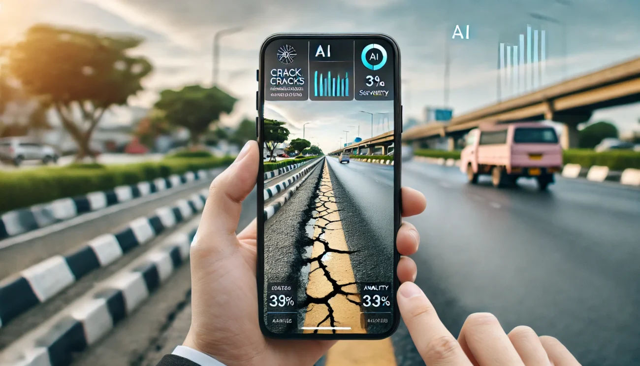
Imagine if the smartphone in your pocket could instantly identify dangerous road conditions, classify them accurately, and report them in real-time. This concept is now becoming reality thanks to researchers who have developed an innovative Automatic Pavement Distress Recognition (APDR) system that works entirely on Android mobile devices.
A study published by A. Tedeschi and F. Benedetto from the Signal Processing for Telecommunication and Economics Lab at the University of Roma, Italy, has demonstrated a promising new approach to automate the detection of common pavement problems. Their system harnesses the power of computer vision technology to transform ordinary smartphones into sophisticated road inspection tools.
Traditionally, road inspections follow a structured approach. Certified inspectors and engineers evaluate roads at regular intervals or after events that might cause surface changes. They measure pavement roughness and assess the magnitude of surface distresses, creating detailed reports that inform maintenance and rehabilitation projects.
These reports play a crucial role in what engineers call Pavement Management Systems (PMS), which help authorities decide when and how to repair roads. However, the manual nature of these inspections introduces inevitable human factors – fatigue, subjective judgment, and simple limitations of what the human eye can detect.
The new smartphone system seeks to enhance, rather than replace, the existing process by offering consistent and objective measurements that support human expertise. By automating certain aspects of the inspection process, road monitoring can occur more often and with increased precision.
The technology driving this innovation utilizes computer vision—the same type of artificial intelligence that enables facial recognition in your photo apps and assists self-driving cars in navigation. However, rather than recognizing faces or obstacles, this system is specifically trained to identify three common types of pavement distresses:
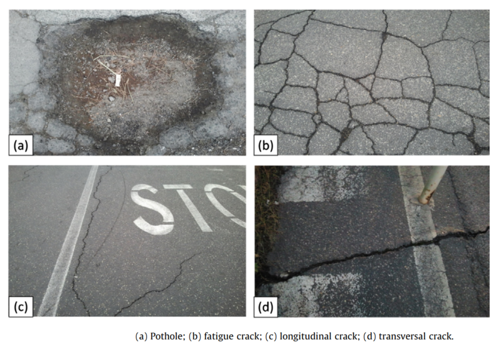
- Potholes : These are bowl-shaped holes that are considered the most recognizable road hazard that can damage your car’s tires and suspension. They form when water seeps into cracks in the pavement and then expands and contracts with temperature changes, gradually breaking apart the road surface. A deep pothole can cause immediate damage to vehicles – from punctured tires to bent wheel rims and even damaged suspensions. For motorcyclists and cyclists, potholes present an even greater danger, potentially causing accidents with serious injuries.
- Longitudinal and Transversal Cracks : These are straight-line cracks that run parallel or perpendicular to the road’s centerline and represent the first stage of more serious road deterioration. Longitudinal cracks run parallel to the road’s centerline, while transversal cracks cut across the road perpendicular to traffic flow. These cracks allow water to penetrate the road base, accelerating damage, especially in regions that experience freezing and thawing cycles.
- Fatigue Cracks (also known as Alligator Cracks) : These are interconnected cracks that form a pattern resembling alligator skin. They typically indicate structural failure beneath the road surface, often due to repeated traffic loading that exceeds the pavement’s design capacity. Areas with these cracks often deteriorate rapidly into potholes if not repaired promptly.
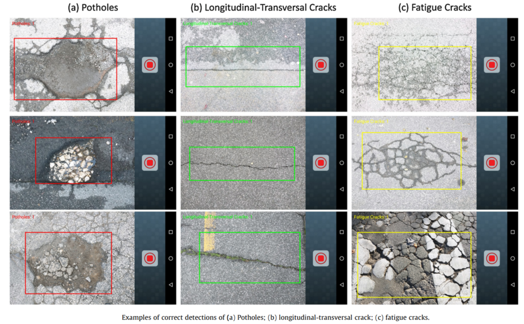
The researchers built their system using the OpenCV library, a powerful open-source computer vision software that can be integrated into mobile applications. This library provides optimized methods for processing images and classifying what they contain. For their specific application, they designed three cascade classifiers based on Local Binary Pattern (LBP) features.
Now, what does that mean in simple terms? Essentially, the system breaks down images captured by your smartphone camera into patterns of pixels. It then compares these patterns against known signatures of different road damages that it has been trained to recognize. When it finds a match, it can identify and classify the type of damage present.
For those curious about the technical details, the system follows a sophisticated computer vision pipeline with six main stages:
- Image acquisition : capturing road surfaces through the smartphone camera
- Pre-processing : enhancing image quality and reducing noise
- Segmentation : identifying regions of interest within the image
- Feature extraction : detecting specific textures or shapes characteristic of pavement distresses
- Object recognition : classifying the type of distress present
- Structural analysis : providing deeper understanding of the detected problem.
The researchers created specialized classifiers for each type of pavement distress. These classifiers act like highly trained experts who can spot specific patterns associated with potholes, cracks, and other defects. The Local Binary Pattern (LBP) features they use are particularly effective for texture analysis, making them ideal for differentiating between different types of road surface anomalies.
The entire system is optimized to run efficiently on mobile devices, enabling real-time detection as users simply point their camera at the road surface. What makes this particularly impressive is that traditionally, this kind of analysis would require powerful computers and couldn’t be performed on-site. By adapting these complex algorithms to work within the constraints of a smartphone’s processing power, the researchers have created a truly portable inspection tool.
The practical applications of this technology extend beyond simple detection. The Android application created by the researchers captures comprehensive data about each detected distress:
- The category of pavement distress identified
- The number of distresses detected in the frame
- Images of the detected distresses
- Date and time of detection
- GPS location of each distress
- This information creates a valuable database of pavement conditions that can be used to:
- Track the degradation of specific road sections over time
- Plan targeted maintenance before small problems become major hazards
- Allocate resources more efficiently by prioritizing the most critical repairs
- Provide objective evidence for infrastructure funding requests
- Evaluate the effectiveness of previous repair methods
Imagine a scenario where a city’s maintenance department equips their vehicles with smartphones running this application. As staff drive their normal routes, the phones automatically scan the roads, building a comprehensive map of pavement conditions throughout the city. Engineers can then analyze this data to identify patterns – perhaps discovering that certain neighbourhoods experience more rapid road deterioration due to soil conditions, drainage issues, or traffic patterns.
For individual users, the application could potentially evolve into a crowdsourced road condition reporting system. Similar to how traffic apps like Waze allow drivers to report accidents or congestion, this technology could enable automatic reporting of dangerous road conditions. Your morning commute could contribute valuable data that helps keep roads safer for everyone.
The researchers extensively tested their system on various Android platforms and achieved impressive results, with more than 0.7 in precision, recall, accuracy, and F-measure for the recognition of pavement distresses. It means the system correctly identifies road damages more than 70% of the time – a significant achievement given the complexity of analyzing varied road surfaces under different lighting and weather conditions.
What makes this system particularly valuable is its ability to reduce subjectivity in road inspections. Traditional manual inspections rely heavily on individual judgment, leading to potential inconsistencies between different inspectors. An automated system applies the same criteria consistently, resulting in more standardized assessments.
Moreover, the time-saving potential is enormous. Manual inspections of road networks can take weeks or months to complete. With mobile detection systems, large portions of road networks can be assessed in days, allowing for more frequent monitoring and earlier intervention when problems arise.
Looking ahead, the development of this mobile pavement distress recognition system represents just one aspect of a broader trend toward smart infrastructure. As cities around the world embrace digital technologies to improve urban management, tools like this will become increasingly important for maintaining critical infrastructure efficiently.
Future iterations of this technology might incorporate additional capabilities, such as estimating the depth of potholes or the severity of cracks, predicting how quickly a distress might worsen, or even suggesting the most appropriate repair method. Integration with other systems – like municipal work order management software or navigation apps – could further enhance its utility.
Tedeschi and Benedetto’s research shows that advanced computer vision technologies can adapt to mobile devices, enhancing infrastructure monitoring. This can improve road management for agencies and increase safety for millions of users. While no automated system can fully replace skilled engineers, the APDR system helps professionals prioritize critical issues and reduce undetected hazardous conditions. As roads age and traffic grows, innovative maintenance approaches are crucial. By leveraging the computational power of our mobile devices, we can make transportation networks safer and more reliable, one scan at a time.
In conclusion, road safety is a global concern, with pavement issues significantly causing accidents. Mobile-based automatic pavement distress recognition systems enhance traditional inspections by allowing more frequent and comprehensive monitoring of our roads. Using advanced computer vision and smartphone technology, researchers have developed a tool that can change how we identify and address dangerous road conditions. As this technology evolves, it promises to improve road safety, potentially saving lives through quicker detection and repair of hazardous pavements. Next time you avoid a pothole, remember the solution for safer roads might be in your pocket.
Reference
Tedeschi, A., & Benedetto, F. (2017). A real-time automatic pavement crack and pothole recognition system for mobile Android-based devices. Advanced Engineering Informatics, 32, 11-25.https://doi.org/10.1016/j.aei.2016.12.004
U.S. Department of Transportation, Traffic Safety Facts – Crash Stats, June 2015.http://www-nrd.nhtsa.dot.gov/Pubs/812160.pdf
European Commission, Road Safety in the European Union, March 2015.http://ec.europa.eu/transport/road_safety/pdf/vademecum_2015.pdf
Tedeschi, A., & Benedetto, F. (2017). A real-time automatic pavement crack and pothole recognition system for mobile Android-based devices. Advanced Engineering Informatics, 32, 11-25.10.1109/ICCEE.2008.96
Mednis, G. Strazdins, R. Zviedris, G. Kanonirs, L. Selavo, Real time pothole detection using Android smartphones with accelerometers, in: International Conference on Distributed Computing in Sensor Systems and Workshops (DCOSS), Barcelona, 2011, pp. 1–6.
Douangphachanh, H. Oneyama, Using smartphones to estimate road pavement condition, in: International Symposium for Next Generation Infrastructure. Wollongong, Australia, October 1-4, 2013