

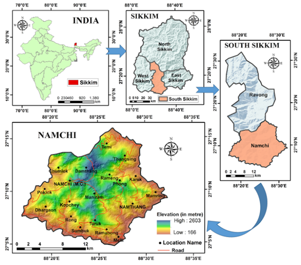
Landslides represent one of the most devastating natural disasters, often resulting in significant loss of human life and severe damage to property. The Namchi region in South Sikkim is particularly susceptible to frequent landslides, which can adversely affect infrastructure, forests, agricultural land, and communities.
Historically, South Sikkim has endured several impactful landslides. Notable events include the catastrophic landslide in 1968 affecting the Turung, Donok, and Seti Khola areas. Subsequent incidents occurred in 2005 along the Manzing section of the Yang-yang-Lingmoo road, in 2007 on the Singtam-Sirwani-Papung road, and in 2017 in the Upper Gursey area, as well as Upper Bokrong, Khorlong, and Lower Kateng Bokrong. Each of these events resulted in numerous casualties and considerable economic and property losses. This ongoing vulnerability highlights the need for continued attention and proactive measures to mitigate the impact of such natural disasters in the region.
As technology continues to advance, researchers are increasingly utilizing Geographic Information Systems (GIS) and remote sensing techniques to identify areas susceptible to landslide hazards. This approach facilitates landslide hazard zonation, which is essential for categorizing and delineating study areas based on the severity of risk. Such zonation is a crucial preliminary step in the planning, management, and mitigation of landslide-related disasters. The primary benefit of employing geospatial techniques lies in their ability to assess nearly every inaccessible region, identify various types of landslides, and determine landslide-prone zones based on significant causative factors.
Numerous studies have utilized heuristic techniques, including the Analytical Hierarchy Process (AHP) and Weighted Linear Combination (WLC), among others. The advantage of employing heuristic methods
lies in their ability to facilitate site-specific and landslide-type-specific evaluations of causal factors, thereby avoiding the generalizations often inherent in data-driven approaches.
In this context, a study authored by Amit Bera et al. from the Department of Earth Sciences at the Indian Institute of Engineering Science and Technology, Shibpur, Howrah, West Bengal, published in the journal Natural Hazards in February 2019, conducted a landslide susceptibility mapping for Namchi, South Sikkim utilizing the AHP method. This approach analyzed the weight values of each thematic layer, assigning relative rating values based on their influence on landslide triggers. The highest weightage was assigned to the slope (= 0.294) and soil (= 0.015). The various thematic layers were rated on a scale of 0 to 9, with higher values indicating a greater potential for landslide occurrence.
To ensure the reliability of the evaluated weightings, the consistency ratio was calculated, with an acceptable threshold of CR < 0.1. The findings indicated a consistency ratio of CR < 0.041, thereby demonstrating that the pairwise comparisons were consistent and the weights assigned were appropriate for the landslide hazard zonation model.
The study examines nine conditioning factors, which include slope, rainfall, earthquake hazard index, lineament density, drainage density, geology, elevation, aspect, land use/land cover, and soil characteristics. A dataset of 52 landslide samples was utilized for the analysis. A landslide hazard zonation map was developed using the Weighted Overlay Index (WOI) method on a GIS platform, specifically employing ArcGIS 10.1 software.
The findings indicate that the area with the highest susceptibility, accounting for 27% of the total study region, falls within the moderate susceptibility category. Conversely, the area classified as having very high susceptibility constitutes only 11% of the total study area but exhibits a significant landslide occurrence rate of 32.7%. Additionally, the landslide frequency in the high-hazard zone is notably high at 23.1%, despite this zone occupying only 19% of the area. Collectively, the very high-hazard and high-hazard zones represent 30% of the total area and encompass 55.8% of all recorded landslide occurrences. In contrast, the very low- and low-hazard zones together comprise 43% of the area, with a landslide occurrence rate of 25%.
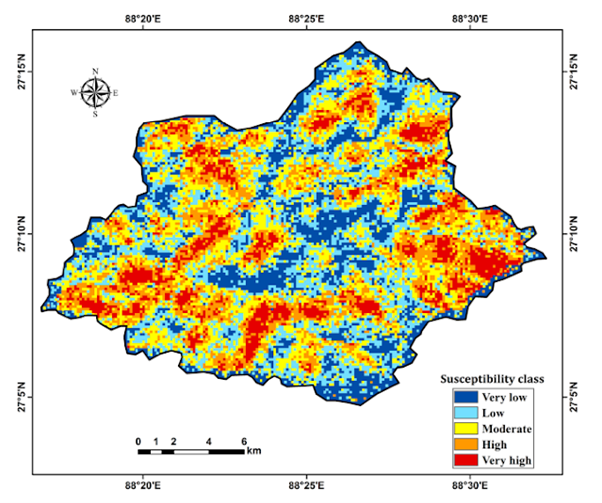
Landslide hazard zonation mapping has been performed using AHP-weighted multi-criteria analysis, integrating remote sensing and GIS techniques. This approach effectively identifies vulnerable zones in areas with limited historical data on landslides. The resulting map categorizes the area into five susceptibility zones and was validated through ground surveys and landslide inventories. To enhance prediction accuracy, additional factors should be incorporated, and updates are necessary due to changes from natural events or human activities. The landslide hazard zonation map of the Namchi region can serve as a foundation for land-use planning and slope management.
Reference
Bera, A., Mukhopadhyay, B.P. & Das, D. Landslide hazard zonation mapping using multi-criteria analysis with the help of GIS techniques: a case study from Eastern Himalayas, Namchi, South Sikkim. Nat Hazards 96, 935–959 (2019). https://doi.org/10.1007/s11069-019-03580-w