
Groundwater represents one of our most valuable natural resources, particularly for agricultural communities. Unlike surface water, groundwater remains relatively protected from pollution, making it an ideal source for both drinking and irrigation purposes. This becomes especially critical during drought seasons when surface water supplies dwindle and crops risk failure without adequate irrigation.
It offers remarkable stability in both quality and quantity when managed properly and can reliably supply the necessary amount of high-quality water even when surface sources fail. This reliability, however, depends on implementing appropriate water conservation plans for sustainable use. Without such plans, communities risk depleting this precious resource through excessive extraction or failing to properly manage aquifer recharge.
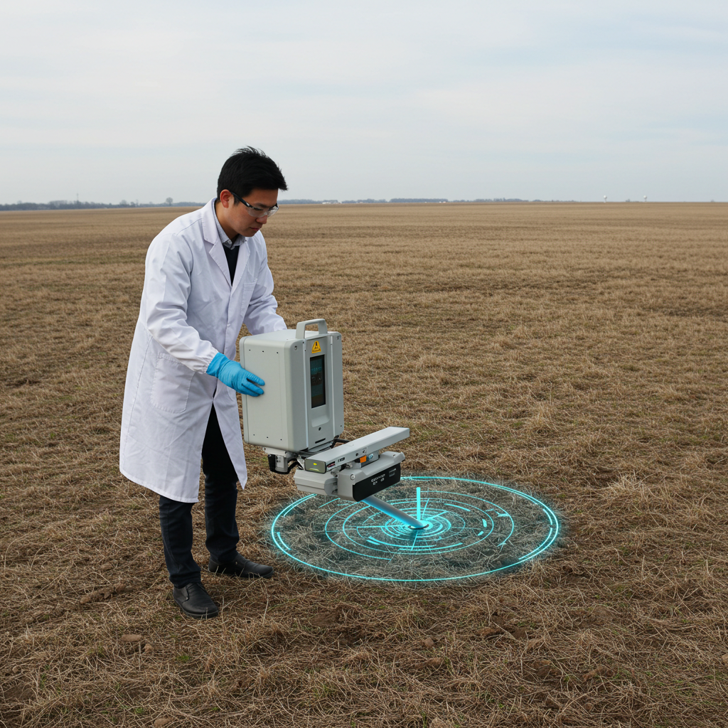
Despite its importance, groundwater presents unique challenges for resource management. Unlike rivers, lakes, or reservoirs that we can directly observe, groundwater remains hidden beneath the earth’s surface. Traditional methods of locating groundwater have typically involved direct drilling for hydrological testing or using complex geophysical models. While these approaches can effectively identify hydrological characteristics of groundwater, they come with prohibitive costs in both time and money.
With advanced satellite technologies like the Gravity Recovery and Climate Experiment (GRACE), which can detect large-scale gravity anomalies related to groundwater, creating detailed local groundwater potential maps remains essential for regional management. Until recently, studies on groundwater distribution have been limited to local scales based on point measurements from sources like meteorological stations, flow measurement points, and groundwater level monitors. The fundamental challenge lies in converting limited point-based data into comprehensive maps that show groundwater potential across entire regions. This is where modern technology offers revolutionary solutions.
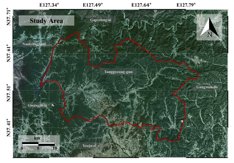
A study conducted by a team of researchers from Korea, in the Yangpyeong-gun where researchers utilized remote sensing data to derive various factors that influence groundwater potential. This region is prone to drought conditions in past years. In 2018, heat waves and drought caused widespread damage to crops throughout the year. The average storage rate in 339 reservoirs in Gyeonggi-do dropped to just 59% of capacity, representing only 76% of normal levels. These conditions highlight why having reliable information about groundwater availability becomes crucial for agricultural sustainability.
Remote sensing technology has transformed our ability to observe and analyze Earth’s resources on a global scale. When applied to groundwater research, remote sensing data can help convert point-based measurements into areal distribution analyses. This approach allows researchers to extend local groundwater hydrological modeling to regional or even global scales, while Geographic Information Systems (GIS) play a crucial role by enabling quantitative analysis of spatial distributions. GIS technologies have become indispensable tools in environmental, geological, and hydrological studies, allowing researchers to integrate and analyze diverse datasets in a spatial context.
Rather than relying solely on traditional statistical methods or expert opinions, the researchers employed advanced algorithms that could learn patterns from existing data and apply those patterns to predict groundwater potential in unmeasured areas.
The study used two primary machine learning approaches: the Frequency Ratio (FR) model and the Boosted Classification Tree (BCT) method. The FR model is a statistical approach that analyzes the relationship between groundwater conditioning factors and actual groundwater potential. It establishes correlations between various environmental factors and known groundwater yields.
The BCT method represents a more sophisticated machine learning approach that can capture complex, non-linear relationships between environmental factors and groundwater potential. This method builds a sequence of decision trees, with each subsequent tree focusing on correcting the errors of previous trees. The result is a highly accurate predictive model that improves with each iteration.
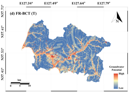
Further, the researchers developed an ensemble model called FR-BCT that combined both approaches. This hybrid methodology leveraged the strengths of both models to achieve even greater accuracy in predicting groundwater potential.
One of the most significant challenges in groundwater mapping is the scarcity of data. In the Yangpyeong-gun study, researchers had access to only 53 well locations with both specific capacity (SPC) and transmissivity (T) data. This limited dataset might seem insufficient for mapping groundwater potential across an entire region of approximately 878 km².
To address this challenge, the researchers employed innovative ensemble learning techniques. These methods, including voting, bagging, and adaptive boosting, allowed them to maximize the value of limited data. The approach works by identifying unlabeled cases via self-learning, combining information from labeled cases so that the labeled training set expands in each iteration until the entire dataset is labeled. This method proved particularly effective for data-scarce areas because it enabled modeling using less data than other approaches would require.
The researchers randomly divided their 53 well locations into two classes: 70% for model training and 30% for testing. This division ensured that the models could be validated against independent data not used in the training process.
The study identified multiple factors that influence groundwater potential in the region. These factors included:
- Topographic factors: Elevation, slope, aspect, plan curvature, profile curvature, topographic wetness index, stream power index, sediment transport index, and distance from rivers.
- Hydrological factors: Flow accumulation and curvature.
- Land cover factors: Forest type, soil material, and land use.
- Geological factors: Lithology and distance from lineaments.
By analyzing the relationship between these factors and known groundwater yields, the researchers could determine which factors had the greatest influence on groundwater potential. Interestingly, the study found that soil was the most influential factor affecting groundwater potential in this region. This insight emphasizes the importance of soil characteristics in determining how water infiltrates and accumulates underground.
The performance of the groundwater potential mapping models was evaluated using the receiver operating characteristic (ROC) method. This statistical approach assesses how well a model distinguishes between positive and negative cases – in this case, areas with high versus low groundwater potential.
The results showed impressive accuracy for both models, but the ensemble FR-BCT model performed particularly well. For specific capacity (SPC) prediction, the area under the ROC curve showed values of 80.48% for the BCT model and 87.75% for the FR-BCT model. For transmissivity (T) prediction, the accuracy rates were 72.27% for the BCT model and 81.49% for the FR-BCT model.
These high accuracy rates confirm that machine learning techniques can effectively model groundwater potential even in areas where data are relatively scarce. The superior performance of the ensemble FR-BCT model demonstrates the value of combining different methodological approaches when tackling complex environmental prediction problems.
The implications of this research extend far beyond academic interest by having accurate groundwater potential maps that can help farmers and water resource managers make informed decisions about where to drill new wells and how to manage existing ones. Consider a practical example: A farming community in Yangpyeong-gun facing drought conditions needs to develop new groundwater sources for irrigation. Without groundwater potential mapping, they might drill multiple expensive wells with disappointing yields. With groundwater potential maps based on this research, they can target areas with high groundwater potential, reducing costs and increasing the likelihood of finding sufficient water resources.
In conclusion, the innovative combination of remote sensing, GIS, and machine learning techniques demonstrated in this study represents a significant advancement in our ability to map and manage groundwater resources. By converting limited point-based measurements into comprehensive regional maps, these approaches reduce uncertainty and provide valuable information for sustainable groundwater management.
Reference
Lee, S., Hyun, Y., Lee, S., & Lee, M.-J. (2020). Groundwater Potential Mapping Using Remote Sensing and GIS-Based Machine Learning Techniques. Remote Sensing, 12(7), 1200. https://doi.org/10.3390/rs12071200
Balbarini, N.; Bjerg, P.L.; Binning, P.J.; Christiansen, A.V. Modelling Tools for Integrating Geological, Geophysical and Contamination Data for Characterization of Groundwater Plumes. Ph.D. Thesis, Department of Environmental Engineering, Technical University of Denmark, Kgs., Lyngby, Denmark, 2017.
Elmahdy, S.I.; Mohamed, M.M. Automatic detection of near surface geological and hydrological features and investigating their influence on groundwater accumulation and salinity in southwest Egypt using remote sensing and GIS. Geocarto Int. 2015, 30, 132–144.
Kim, J.-C.; Jung, H.-S.; Lee, S. Groundwater productivity potential mapping using frequency ratio and evidential belief function and artificial neural network models: Focus on topographic factors. J. Hydroinformatics 2018, 20, 1436–1451.