

Introduction
Floods affect over 1.5 billion people globally, causing thousands of deaths and $50 billion in annual damages. Traditional flood prediction methods struggle with data scarcity and slow response times, especially in developing regions. Google’s AI-Based Global Flood Forecasting System tackles these challenges by combining machine learning, satellite data, and real-time weather modeling to deliver actionable flood warnings up to 7 days in advance. Here’s how it works and why it matters.
Google’s AI-Based Global Flood Forecasting System represents a significant advancement in flood prediction technology, addressing critical limitations of traditional methods. By leveraging machine learning algorithms, the system can analyze vast amounts of satellite imagery and historical flood data to identify patterns and predict future flood events with greater accuracy. This approach is particularly valuable in regions where ground-based sensors and historical records are limited, enabling more comprehensive global coverage.
The system’s integration of real-time weather modeling enhances its predictive capabilities, allowing it to account for rapidly changing atmospheric conditions that can influence flood development. By providing actionable warnings up to a week in advance, communities and authorities have more time to implement evacuation plans, reinforce flood defenses, and protect critical infrastructure. This extended lead time can significantly reduce the loss of life and economic impact associated with flood events. Moreover, the system’s ability to deliver targeted, location-specific alerts helps prioritize resources and focus mitigation efforts where they are most needed, potentially revolutionizing flood management strategies worldwide.
How the System Works
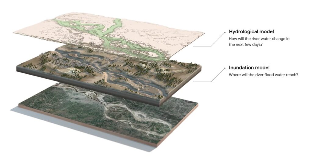
Google’s system uses two interconnected AI models:
Hydrologic Model
The hydrologic model integrates various inputs, including precipitation forecasts, temperature data, river basin characteristics, and historical flood patterns, to generate accurate predictions of river behavior. Its architecture is based on Long Short-Term Memory (LSTM) networks, which are specifically designed to analyze time-series data. This structure allows the model to process complex temporal relationships in hydrological systems, considering both short-term fluctuations and long-term trends. By leveraging these advanced neural network techniques, the model produces outputs that forecast river water levels and discharge rates. These predictions are crucial for water resource management, flood preparedness, and environmental planning, providing valuable insights into future river conditions and potential flood risks.
Inundation Model
The inundation model integrates hydrologic forecasts with high-resolution satellite imagery and elevation maps to predict flooding. It employs two main methods: thresholding and the manifold model. Thresholding identifies flood-prone areas by analyzing historical water levels, while the manifold model uses geometric simulations to predict both flood extent and depth. The output of this model is a set of detailed street-level flood maps, providing valuable information for flood risk assessment and management. These maps offer a visual representation of potential inundation areas, allowing for better preparedness and response planning in flood-prone regions.
These models work in tandem to provide warnings through Google Search, Maps, and direct Android alerts.
Technical Breakthroughs
Extended Lead Time
The extended lead time in weather forecasting represents a significant advancement in meteorological technology. While earlier systems typically provided 5-day forecasts, Google’s 2024 upgrade has substantially expanded this capability. A key feature of this upgrade is the integration of Google DeepMind’s weather model, which has markedly improved medium-range precipitation forecasts. This integration allows for more accurate predictions of rainfall patterns and intensity over longer periods, enhancing the reliability of weather forecasts beyond the traditional 5-day window. Additionally, the upgrade incorporates a countable mixture of asymmetric Laplacians (CMAL) distribution. This sophisticated statistical approach is utilized to quantify uncertainty in weather predictions. The CMAL distribution enables meteorologists to provide more nuanced and probabilistic forecasts, offering a range of possible outcomes rather than a single deterministic prediction. This approach acknowledges the inherent variability in weather systems and provides users with a more comprehensive understanding of potential weather scenarios, thereby improving decision-making processes for various sectors reliant on accurate weather information.
Virtual Gauges
Virtual gauges represent a significant advancement in flood monitoring and risk assessment, particularly in regions where physical sensors are absent or impractical to install. By leveraging artificial intelligence and geological data, these simulated gauges provide crucial insights into river behavior across diverse geographical locations. The implementation of over 250,000 virtual gauges has dramatically expanded flood risk monitoring capabilities, now covering 150 countries. This extensive network allows for more comprehensive and accurate predictions of potential flooding events in areas previously unmonitored. The virtual gauges analyze various factors, including topography, soil composition, precipitation patterns, and historical flood data, to create models that simulate river flow and water levels. This approach not only enhances early warning systems but also aids in long-term flood management strategies and urban planning. By providing data for areas that were previously blind spots in flood monitoring, virtual gauges contribute significantly to improving global resilience against flood-related disasters and support more informed decision-making in water resource management.
Scalable Training
The LSTM model’s scalable training has significantly expanded its global reach and impact. By incorporating data from 3 times more global locations than previous versions, the model now encompasses diverse river conditions from major waterways like the Amazon and Ganges. This enhanced coverage has extended protection to 700 million people across more than 100 countries, a substantial increase from the 460 million protected in 2023. The system’s effectiveness was demonstrated during the 2024 Rio Grande do Sul floods in Brazil, where it rapidly added over 200 locations to Flood Hub within hours, providing crucial support for rescue operations. To further advance flood prediction research and applications, the GRRR dataset (1980-2023) and a public API have been made available, allowing researchers to access valuable historical and real-time data for their studies and interventions.
Challenges and Future Goals
Data gaps in remote areas continue to pose challenges for model fine-tuning, limiting the accuracy of flood forecasts in certain regions. Despite these obstacles, Google has set an ambitious goal to expand its flood forecasting system to cover all flood-prone areas worldwide. The company also aims to integrate these forecasts with alerts for other climate-related disasters such as droughts and wildfires. This comprehensive approach aligns with Google’s vision of creating a future where extreme weather events no longer catch people off guard.
By combining artificial intelligence with global collaborative efforts, Google’s system demonstrates the potential of technology to transform disaster response from a reactive approach to a proactive one. As climate change intensifies the frequency and severity of floods across diverse regions, from Valencia to West Africa, the importance of such forecasting tools becomes increasingly evident. Google’s flood forecasting system serves as a critical lifeline for vulnerable communities, showcasing how AI, when developed with a focus on human needs and well-being, can play a significant role in saving lives and mitigating the impacts of natural disasters.
Reference
- Google. (2024, March 20). How we are using AI for reliable flood forecasting at a global scale. Google Blog. https://blog.google/technology/ai/google-ai-global-flood-forecasting/
- Google. (2024, November 11). How Google helps others with AI flood forecasting. Google Blog. https://blog.google/technology/ai/expanding-flood-forecasting-coverage-helping-partners/
- InsurTech Digital. (2024, November 17). Google expands AI flood forecasting globally. https://insurtechdigital.com/articles/google-expands-ai-powered-flood-forecasting
- Donghyun Kim, Jong-Pyo Park, Heechan Han, Haneul Lee, H. Kim, Soojun Kim. (2023, May 5). Application of AI-based models for flood water level forecasting and flood risk classification. https://www.semanticscholar.org/paper/43e026229664fda1a13417938b71316c14dea9ad
- Dr Srinivasa Rao Kadari, Dr. P. Ravichandra, M. Shekar, D. Neetha. (2024, December 7). Artificial intelligence (AI) to build climate models to improve weather forecasting as torrential rains, floods, and droughts proliferate across the vast country. https://www.semanticscholar.org/paper/aa17e7759573adb6f95eff7046f4affaf5fd2acc
The Financial Technology Report. (2025, March 11). Google’s improved flood forecasting helps global communities prepare for disasters. https://thefinancialtechnologyreport.com/googles-improved-flood-forecasting-helps-global-communities-prepare-for-disasters/
ESG News. (2024, March 22). Advancing global flood forecasting with AI: Google Research’s breakthrough. https://esgnews.com/advancing-global-flood-forecasting-with-ai-google-researchs-breakthrough/
YourStory. (2024, March 31). Google’s AI model: A dam good way to predict floods 7 days early. https://yourstory.com/2024/03/googles-ai-model-dam-good-way-predict-floods-7-days-early
Business Today. (2024, November 14). Google expands AI-driven flood forecasting to cover 700 million people in 100 countries. https://www.businesstoday.in/technology/news/story/google-expands-ai-driven-flood-forecasting-to-cover-700-million-people-in-100-countries-453699-2024-11-14