

Introduction
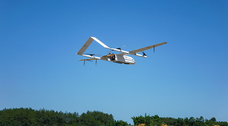
The utilization of advanced drone technology in Malaysia’s tropical highlands represents a significant leap forward in infrastructure development and risk management. The CW-25E electric VTOL drone, coupled with the JoLiDAR-LR22S sensor, proved to be a game-changer in mapping the challenging 45 km border road. This innovative approach not only expedited the survey process but also provided unprecedented accuracy in data collection. The high-resolution 3D point clouds, with their impressive 5 cm/pixel resolution, offered engineers a detailed and comprehensive view of the terrain, allowing for precise identification of potential hazards and unstable slopes.
This technological advancement has far-reaching implications for highway construction projects in geographically complex regions. By enabling engineers to design targeted preventive measures, the drone survey significantly enhances the safety of both construction workers and nearby communities. Moreover, this approach likely reduces the overall project timeline and costs associated with traditional survey methods, while simultaneously improving the quality and reliability of the data collected. The success of this project in Malaysia serves as a compelling case study for the integration of drone technology in infrastructure development, particularly in areas prone to natural disasters such as landslides. It showcases how cutting-edge technology can be effectively employed to overcome environmental challenges and ensure the longevity and safety of critical infrastructure projects.
The Challenge: Landslides in Tropical Terrain
Malaysia’s mountainous regions present a unique set of challenges for landslide monitoring and risk assessment. The combination of heavy monsoon rains, dense tropical vegetation, and complex geological formations creates an environment highly susceptible to landslides. These factors not only increase the frequency of landslide occurrences but also make it difficult to predict and monitor potential hazard zones effectively. The dense forest canopy often obscures the ground surface, limiting the effectiveness of satellite-based remote sensing techniques. Additionally, the steep and often inaccessible terrain makes traditional ground-based surveys both dangerous and time-consuming.
To address these challenges, there is a pressing need for innovative approaches that can overcome the limitations of conventional surveying methods. An ideal solution would need to provide high-resolution data capable of penetrating the forest canopy, operate efficiently in challenging terrain, and deliver results quickly enough to support timely decision-making. Such a system would need to be adaptable to the harsh tropical conditions, including high humidity and frequent rainfall, while also being cost-effective and scalable for large-area surveys. The development of such a solution could significantly enhance landslide risk management in Malaysia and potentially in other regions with similar geographical and climatic characteristics.
The Technology: CW-25E Drone + JoLiDAR-LR22S
1. CW-25E Electric VTOL Drone
- Endurance: 210-minute flight time per charge, critical for covering large areas (14 flights over 10 days).
- Payload Capacity: 6 kg, sufficient to carry the JoLiDAR-LR22S and its peripherals.
- Environmental Adaptability: Operates in high humidity, light rain, and temperatures of up to 40°C, making it ideal for Malaysia’s climate.
- Precision Landing: Autonomous takeoff/landing with <15 cm accuracy, ensuring repeatable data collection.
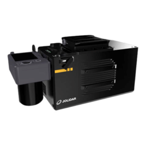
2. JoLiDAR-LR22S LiDAR Sensor
- Scanning Range: 1,845 meters at 80% reflectivity, penetrating dense canopy to map ground surfaces.
- Point Density: 1.5 million points/second and 15 returns per pulse, capturing terrain details under vegetation.
- Accuracy: Vertical accuracy ≤3 cm, horizontal ≤5 cm, paired with RTK-GPS for georeferencing.
- 61MP Camera: Supplemented LiDAR data with high-resolution RGB imagery for visual validation.
Implementation: From Data to Decisions
Phase 1: Survey Design
Engineers carefully planned flight paths to cover the highway corridor, focusing on areas with slopes greater than 30 degrees and locations with a history of landslide activity. The CW-25E’s modular design proved advantageous, enabling rapid assembly in remote base locations. This strategic approach allowed for efficient surveying of high-risk areas while maximizing the drone’s capabilities in challenging terrain.
Phase 2: Data Collection
Each 210-minute flight covered approximately 3.2 km, with the drone flying at 82.8 km/h at an altitude of 150 meters to achieve a ground sample distance (GSD) of 5 cm/pixel. The LiDAR system’s 360-degree field of view ensured complete coverage, even in tight spaces. This configuration allowed for efficient data collection, capturing high-resolution imagery and detailed topographic information across the surveyed area. The combination of the drone’s speed, altitude, and the LiDAR’s wide field of view enabled comprehensive mapping of the terrain, including potentially challenging or confined areas that might be difficult to survey using traditional methods.
Phase 3: Analysis & Action
3D point clouds, processed using software like TerraSolid, provide valuable insights into slope angles, soil erosion patterns, and groundwater pathways. This data analysis facilitates risk identification, allowing engineers to flag steep slopes with clay-rich soils that are prone to saturation. In response to these identified risks, engineers design retaining walls and drainage channels to stabilize vulnerable zones. The continuous monitoring of deformation trends in the point cloud data serves as an early warning system, alerting teams to pre-failure slopes and enabling proactive measures to mitigate potential landslides.
Results: Safety Through Precision
The implementation of an early warning system for landslides has yielded significant benefits for communities in high-risk areas. During periods of heavy rainfall, over 200 residents living near vulnerable zones received timely alerts, enabling them to take necessary precautions and evacuate if required. This proactive approach to disaster management has not only enhanced public safety but also resulted in substantial cost savings. By averting potential landslide-related damages, the project has prevented an estimated $2 million or more in repair and reconstruction expenses.
Furthermore, the initiative has contributed to long-term disaster preparedness and risk reduction efforts. The data collected through this system has been integrated into a national landslide monitoring database, providing valuable insights for future hazard assessments and mitigation strategies. This comprehensive approach to landslide risk management demonstrates the effectiveness of combining technology, community engagement, and data-driven decision-making in building resilience against natural disasters.
Conclusion
This project showcases how drone-LiDAR partnerships can transform landslide risk management in challenging environments. By marrying the CW-25E’s reliability with JoLiDAR’s precision, the team turned raw data into actionable insights—protecting lives and ensuring Malaysia’s highways stand firm against nature’s forces. As climate change intensifies rainfall, such scalable solutions will be vital for tropical nations worldwide.
Reference
- CHC Navigation. (2023). CW-25E Electric Fixed-Wing VTOL UAV: Product Brochure. https://www.chcnav.com/products/cw-25e
- JoLiDAR. (2023). JoLiDAR-LR22S Airborne LiDAR System: Technical Specifications. https://www.jolida.com/products/lr22s
- TerraSolid Ltd. (2024). TerraSolid Software Suite: User Guide. https://www.terrasolid.com/products/terrasolid-software-suite/
- Malaysian Public Works Department. (2022). Guidelines for Slope Management and Landslide Risk Assessment in Malaysia. https://www.jkr.gov.my/
- Rahman, Z. A., & Lateh, H. (2017). Landslide hazard and risk assessment in Malaysia: A review. Geoscience Frontiers, 8(5), 1015-1026. https://doi.org/10.1016/j.gsf.2016.08.001
- Tan, S. L., & Pradhan, B. (2014). LiDAR applications in landslide studies in tropical regions. Natural Hazards, 70(1), 1-20. https://doi.org/10.1007/s11069-013-0792-2