

When you turn on your faucet, have you ever wondered about the journey that water took to reach your glass? For many communities worldwide, groundwater is the invisible lifeline flowing beneath our feet. But this precious resource faces growing threats from contamination, particularly from nitrates found in fertilizers, sewage, and industrial waste. In this article I’ll be sharing some exciting research that’s changing how we protect this vital resource.
Groundwater contamination is a silent crisis affecting communities worldwide. Unlike surface water pollution that we can often see and smell, groundwater contamination happens out of sight. By the time it’s detected in drinking wells, the damage is already done.
A study focuses on Miryang City, South Korea, where researchers faced a challenging situation. This area serves as a perfect case study because it combines both urban and rural activities, including city sewage systems alongside agricultural fields and livestock operations. Nitrate contamination was widespread throughout the region, posing a threat to the water supply for over 100,000 residents.
Think of groundwater vulnerability assessment as a health checkup for underground water. It helps us identify which areas are most at risk before contamination occurs. This proactive approach allows water managers to implement protective measures where they’re needed most.
The traditional method for this assessment, known as DRASTIC (an acronym for Depth to water, net Recharge, Aquifer media, Soil media, Topography, Impact of vadose zone, and hydraulic Conductivity), has been the industry standard for decades. However, it’s not without flaws, like trying to diagnose a medical condition with outdated equipment; DRASTIC sometimes falls short because it relies on subjective weightings of various factors.
This is where artificial intelligence enters the picture. Researchers from Pukyong National University in South Korea, along with international collaborators, developed an innovative approach combining the Adaptive Neuro-Fuzzy Inference System (ANFIS) with optimization algorithms.
In simpler terms, they created smart models that learn from existing contamination data to make better predictions about vulnerable areas. Think of it like how Netflix learns your viewing preferences to recommend shows you might enjoy, but instead, these models learn which combinations of environmental factors lead to groundwater contamination.
The research team first improved the traditional DRASTIC model by adding an eighth factor: land use. This makes perfect sense when you think about it. The way we use land, whether for farming, factories, or housing, significantly impacts what contaminants might seep into groundwater.
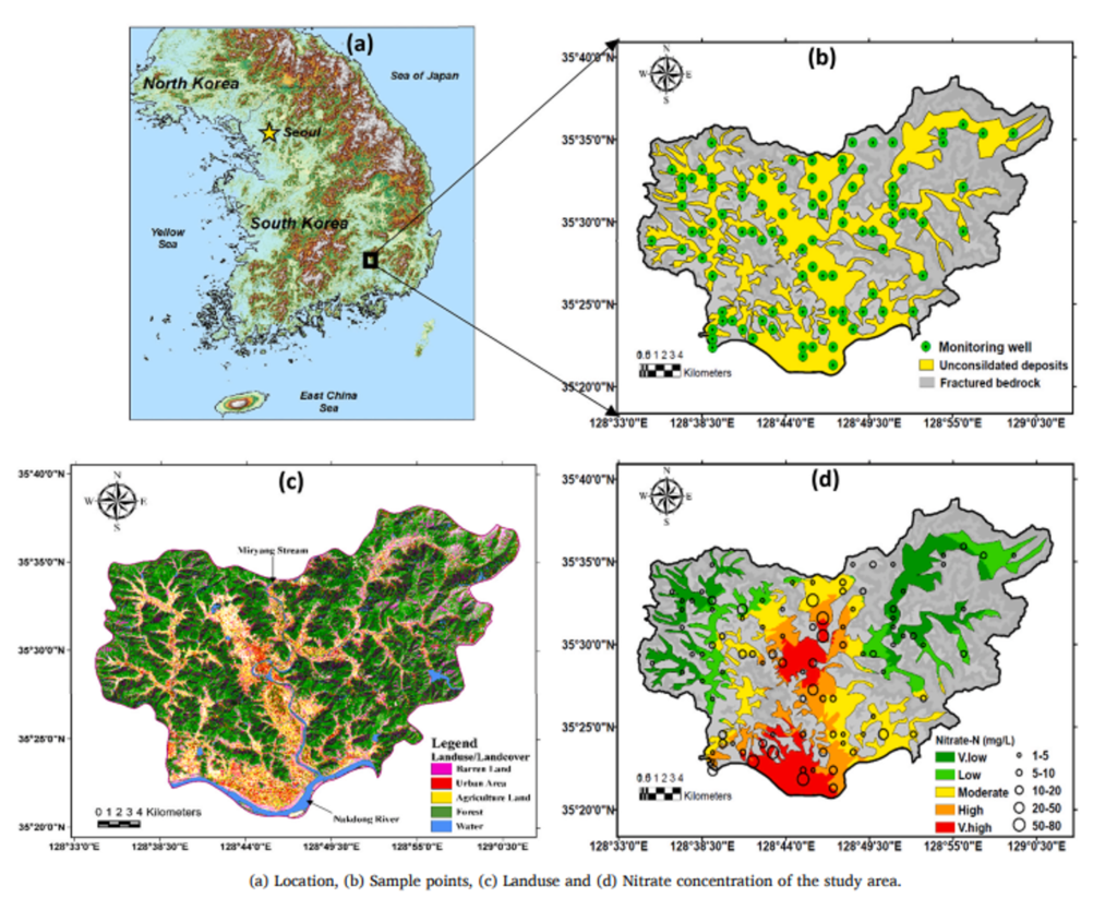
For instance, in Miryang City, areas with intensive agriculture showed higher nitrate levels due to fertilizer application, while urban areas had contamination linked to leaking sewage systems. By incorporating land use patterns, the model could better reflect real-world conditions.
The researchers then tested four different models:
- The original ANFIS model
- ANFIS combined with Genetic Algorithm (ANFIS-GA)
- ANFIS with Differential Evolution (ANFIS-DE)
- ANFIS with Particle Swarm Optimization (ANFIS-PSO)1
These might sound like complicated terms, but essentially, they’re different approaches to helping the AI learn more effectively. Think of them as different training methods for an athlete; all aim to improve performance but take different paths to achieve it.
After rigorous testing involving 95 groundwater samples from the study area, ANFIS-PSO emerged as the clear champion. This model produced the most accurate predictions of groundwater vulnerability to nitrate contamination.
What makes ANFIS-PSO special? This approach mimics how birds flock or fish school, with particles (potential solutions) moving through a search space and communicating their findings to others. This collective intelligence helps the model find optimal solutions more efficiently.
The practical implication is significant as water resource managers using this model can more accurately identify high-risk areas and allocate protection resources more effectively.
Imagine you’re a water manager in a city like Miryang. With limited resources, you need to decide where to focus your groundwater protection efforts. The ANFIS-PSO model could generate a vulnerability map showing exactly which neighborhoods or agricultural areas face the highest contamination risk.
For example, the model might reveal that an area where shallow groundwater meets intensive agriculture and permeable soil is at extreme risk, while a region with deeper groundwater and forest cover remains relatively protected. Armed with this information, you could implement targeted measures like stricter fertilizer regulations in high-risk zones or prioritize sewer system inspections in vulnerable urban areas.
Beyond Miryang City, this research has global implications. Groundwater provides drinking water for approximately 2.5 billion people worldwide. As climate change and population growth stress our water resources, tools like ANFIS-PSO could help communities worldwide protect their underground water supplies.
The research team even compared their models with ten other popular worldwide models and found their ANFIS-MOA approaches superior in performance. This suggests we’re witnessing a significant advancement in how we assess and protect groundwater.
As we face increasing challenges to our water security, innovative approaches like those developed by Elzain and colleagues offer hope. By combining traditional hydrogeological knowledge with cutting-edge artificial intelligence, we’re developing better tools to protect the water beneath our feet.
Reference
Elzain HE, Chung SY, Park KH, Senapathi V, Sekar S, Sabarathinam C, Hassan M. ANFIS-MOA models for the assessment of groundwater contamination vulnerability in a nitrate contaminated area. J Environ Manage. 2021 May 15;286:112162. doi: 10.1016/j.jenvman.2021.112162.
Assessment and mapping of groundwater vulnerability to pollution: current status and challenges.Earth Sci. Rev., 185 (2018), pp. 901-927, 10.1016/j.earscirev.2018.08.009
Development and application of a novel method for regional assessment of groundwater contamination risk in the Songhua River Basin Sci. Total Environ., 605 (2017), pp. 598-609, 10.1016/j.scitotenv.2017.06.126
Mapping vulnerability of multiple aquifers using multiple models and fuzzy logic to objectively derive model structures.Sci. Total Environ., 593 (2017), pp. 75-90, 10.1016/j.scitotenv.2017.03.109