

Floods remain one of nature’s most devastating and frequent disasters, affecting millions of people worldwide each year. According to UN reports, annual global losses from floods reach a staggering 104 billion USD, with approximately 1.81 billion people—23% of the world’s population—directly exposed to significant flood risks. As our climate continues to change and extreme weather events become more common, the ability to predict flood-prone areas has never been more crucial. The article discusses some fascinating research that’s using cutting-edge artificial intelligence to tackle this pressing challenge.
As climate change continues to intensify rainfall patterns, we are witnessing increasingly severe and unpredictable weather events. This situation is further complicated by urban development, which often replaces natural drainage systems with concrete structures that hinder the absorption of rainwater. As a result, the risk of flooding is on the rise, posing significant challenges for many metropolitan areas.
Looking ahead to 2050, projections indicate that approximately 68% of the global population will reside in urban environments. Unfortunately, many of these cities are ill-equipped to handle the heightened risks associated with increased flooding. Factors such as inadequate infrastructure, lack of effective drainage systems, and rapid growth without sufficient planning contribute to their vulnerability.
This convergence of climate change and urbanization creates a critical scenario where flood prediction becomes not just an advantage, but an absolute necessity. Developing accurate forecasting methods and implementing proactive measures will be vital for safeguarding lives and protecting property from the devastating impacts of flooding. Without these efforts, communities may face dire consequences as they struggle to cope with the realities of a changing climate.
Historically, predicting floods has relied on three main approaches. First, statistical analysis uses regression of time series data from gauged stations. Second, rainfall-runoff models employ mathematical equations to simulate how floods spread. Both methods can be accurate but require long-term data from gauged stations with return periods, which isn’t always available. The third approach is newer and doesn’t rely on gauged station data. It uses an ‘on-off’ binary classification, where ‘on’ represents known flood locations and ‘off’ represents non-flood locations. When combined with machine learning, this approach has shown tremendous promise.
Advancements in computational techniques have significantly enhanced the ability to create detailed flood susceptibility maps, with deep learning emerging as a particularly powerful tool in this field. Among the various deep learning methodologies, Convolutional Neural Networks (CNNs) have gained recognition for their effectiveness in analyzing spatial data for flood risk assessments.
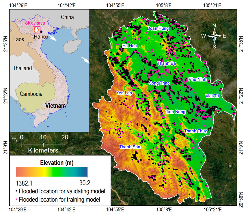
A noteworthy study conducted by researchers Laura Melgar-García, Francisco Martínez-Álvarez, Dieu Tien Bui, and Alicia Troncoso from Norway delved into the application of three distinct CNN architectures to predict areas vulnerable to pluvial flooding in northern Vietnam (Phu Tho Province). This region is often subject to significant rainfall and flooding, making accurate risk mapping essential for effective disaster management and urban planning.
The three CNN architectures investigated in this research were U-Net, WU-Net, and U-Net++. All of these models are designed based on a conventional “u-shaped architecture”, which is particularly advantageous for image segmentation tasks. This design facilitates the precise identification of flood-prone areas on geographic maps by allowing the models to capture both contextual and detailed information from the input images.
Through this approach, the study aimed to enhance the understanding of flood susceptibility in the region, ultimately contributing to more informed decision-making regarding flood preparedness and response strategies. The use of these sophisticated deep learning models signifies a significant step forward in leveraging technology to address environmental challenges such as flooding.
Let me break down how these models work without getting too technical. Imagine you’re looking at a detailed map with various layers of information—elevation, slope, distance to rivers, rainfall patterns, and so on. These models analyze all these factors simultaneously to determine which areas are most likely to flood.
U-Net, originally developed in 2015 for biomedical image segmentation, works like this:
- The model takes a map with various flood indicators as input.
- The “contracting path” (left side of the U) captures the context by progressively reducing the spatial dimensions while increasing feature dimensions. This is like zooming out to see the big picture.
- The “expanding path” (right side of the U) gradually increases spatial dimensions while decreasing feature dimensions, allowing precise localization of flood-prone areas. This is like zooming back in with new understanding.
- Skip connections between the paths preserve important details that might otherwise be lost.
WU-Net is a variation that uses wider convolution layers, allowing it to capture more features at each level. This is particularly useful for flood prediction, where the relationships between geographical and hydrological features are complex.
U-Net++, the newest of the three, enhances the original design by adding nested, dense skip connections between the encoder and decoder parts of the network. These connections help bridge the semantic gap between different levels of features, potentially leading to more accurate predictions.
The researchers conducted an in-depth study by applying advanced predictive models to a tropical region located in northern Vietnam (Phu Tho Province). This area was chosen due to its vulnerability to flooding, and the analysis was supported by a comprehensive geospatial database that documented 796 historical flood locations. In addition to these historical data points, the researchers utilized 12 specific flood indicators that are critical in understanding flood dynamics. These indicators encompassed a range of factors, such as elevation levels, land slope, distance to rivers, rainfall patterns over time, soil composition, and land use/land cover dynamics. By incorporating such diverse indicators, the researchers aimed to capture the multifaceted nature of flood risk in the region.
For the training of the models, they employed binary cross-entropy as the loss function. This choice was essential as it acts as a measure of the prediction error, helping to quantify how well the model’s output aligns with the actual flood occurrences. Alongside this, the ADAM optimization algorithm was utilized, which is known for its capability to adaptively adjust the learning rates for different parameters throughout the training process. This adjustment enhances the efficiency and effectiveness of the learning procedure, allowing the models to converge on optimal solutions more rapidly.
The evaluation of model performance focused on two key metrics essential in predictive modelling: the F1-score and classification accuracy. The F1-score serves as an important indicator, as it provides a balance between precision and recall, ensuring that the models not only accurately predict flood-prone areas but also minimize false positives and negatives. The findings were remarkable; all three models under consideration achieved a high classification accuracy of 96.01%. This impressive performance indicates that the models were successful in correctly identifying flood-prone areas with a significant degree of reliability, underscoring the robustness of the methodologies employed in this study.
So what does this mean in practical terms? Let’s consider some real-world applications:
Imagine you’re a city planner in a flood-prone region like central Vietnam. With these flood susceptibility maps, you could:
- Identify high-risk areas where new development should be restricted
- Design better drainage systems in moderately risky areas
- Create targeted emergency response plans for the most vulnerable neighborhoods
- Allocate resources more efficiently during flood events
In Thailand, similar flood prediction models have helped authorities manage the severe flooding that occurs during the rainy season. By knowing which areas are most susceptible, they can pre-position rescue resources, plan evacuation routes, and implement early warning systems more effectively.
Despite the impressive results, these models face some challenges. Data quality and availability remain significant hurdles, especially in developing countries where detailed historical flood data may be limited.
The dynamic nature of flood factors also presents challenges. As land use changes with new development or deforestation, flood patterns can shift. Models need regular updates to remain accurate. Climate change further complicates matters by altering rainfall patterns, potentially making historical data less predictive of future events.
The research demonstrates the immense potential of deep learning for predicting flood-prone areas with high accuracy. As computing power increases and more data becomes available, these models will likely become even more accurate and widely applicable.
Future developments could include:
- Integration with real-time rainfall data for dynamic predictions during storm events
- Combination with climate models to account for changing rainfall patterns
- Extension to other types of floods, such as fluvial (river) floods or coastal flooding
- Application to urban planning and infrastructure design to create more flood-resilient cities
In Jakarta, Indonesia, which experiences frequent urban flooding due to its low-lying position and rapid urbanization, authorities are already exploring the use of AI-based flood prediction. By identifying the neighborhoods most susceptible to pluvial flooding, they can prioritize infrastructure improvements where they’re most needed.
On a more personal level, these flood susceptibility maps could help individuals make informed decisions. Imagine being able to check a detailed flood risk map before buying a home, much like you might check crime statistics or school ratings.
In Manila, they did exactly this after their flooding experience, using a similar (though less advanced) flood hazard map to find a new apartment in an area with lower flood risk. “It gives us peace of mind,” they said. “Even though the rent is slightly higher, we don’t worry about losing my belongings every rainy season.”
The research on using U-Net, WU-Net, and U-Net++ for flood prediction represents a significant advance in our ability to prepare for one of nature’s most common and destructive hazards. With accuracy exceeding 96%, these models demonstrate the power of deep learning in addressing complex environmental challenges.
As we face an uncertain future with changing climate patterns and growing urban populations, tools like these will be increasingly valuable for disaster management, urban planning, and individual decision-making. While challenges remain in terms of data availability and model adaptability, the potential benefits in lives saved and economic losses avoided are enormous.
The journey from traditional flood prediction methods to these sophisticated deep learning approaches illustrates how rapidly AI is transforming disaster management. For communities in flood-prone regions worldwide, these developments offer new hope for a safer, more resilient future—one where we can predict and prepare for floods before the waters begin to rise.
In the words of a researcher, “The technology is ready. Now we need to ensure it reaches the communities that need it most.” As these models become more accessible and widely implemented, we can look forward to more effective flood risk management and, ultimately, fewer tragic stories of lives and livelihoods lost to flooding.
Reference
Melgar-García, L., Martínez-Álvarez, F., Tien Bui, D., & Troncoso, A. (2023). A novel semantic segmentation approach based on U-Net, WU-Net, and U-Net++ deep learning for predicting areas sensitive to pluvial flood at tropical area. International Journal of Digital Earth, 16(1), 3661-3679.https://doi.org/10.1080/17538947.2023.2252401
Nkwunonwo, U. C., M. Whitworth, and B. Baily. 2020. “A Review of the Current Status of Flood Modelling for Urban Flood Risk Management in the Developing Countries.” Scientific African 7: e00269. https://doi.org/10.1016/j.sciaf.2020.e00269
Santiago-Collazo, Félix L., Matthew V. Bilskie, and Scott C. Hagen. 2019. “A Comprehensive Review of Compound Inundation Models in Low-Gradient Coastal Watersheds.” Environmental Modelling & Software 119: 166–181. https://doi.org/10.1016/j.envsoft.2019.06.002
Hosseini, Farzaneh Sajedi, Shahram Khalighi Sigaroodi, Ali Salajegheh, Alireza Moghaddamnia, and Bahram Choubin. 2021. “Towards a Flood Vulnerability Assessment of Watershed Using Integration of Decision-Making Trial and Evaluation Laboratory, Analytical Network Process, and Fuzzy Theories.” Environmental Science and Pollution Research 28 (44): 62487–62498. https://doi.org/10.1007/s11356-021-14534-w
Liu, Liangliang, Jianhong Cheng, Quan Quan, Fang-Xiang Wu, Yu-Ping Wang, and Jianxin Wang. 2020. “A Survey on U-shaped Networks in Medical Image Segmentations.” Neurocomputing 409: 244–258. https://doi.org/10.1016/j.neucom.2020.05.070