
Introduction
Falls from height continue to be a persistent and deadly threat in the construction industry, with their impact felt worldwide. The staggering statistic of 36% of industry deaths attributed to falls underscores the urgent need for more effective safety measures. Traditional safety protocols, while important, have proven insufficient in fully addressing this issue due to their reliance on manual inspections. These human-led checks are inherently limited by factors such as inspector fatigue, time constraints, and the inability to maintain constant vigilance, often resulting in overlooked transient hazards that can have catastrophic consequences.
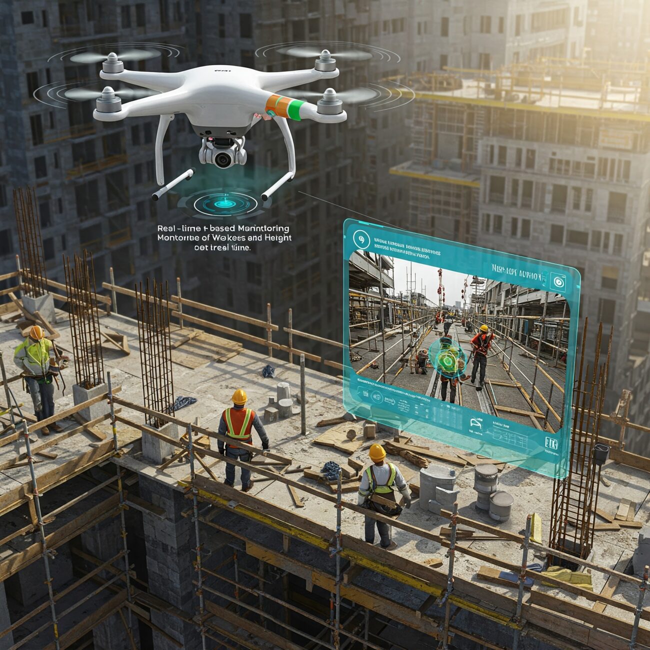
To combat this pressing safety concern, an innovative approach has been developed that leverages cutting-edge technology. This system combines the aerial capabilities of drones with the analytical power of deep learning algorithms. By utilizing drones for continuous aerial surveillance of construction sites, the system can capture real-time data on worker activities, equipment placement, and potential hazards. The deep learning component then processes this data, instantly identifying safety violations such as improperly secured harnesses or workers entering restricted areas. This technological solution promises to significantly enhance safety monitoring capabilities, potentially reducing fall-related fatalities and injuries in the construction industry.
System Architecture: Eyes in the Sky + AI Brain
- Drone Fleet Configuration : The drone fleet configuration consists of custom-built quadcopters equipped with advanced hardware components. Each drone features a 4K RGB camera capable of capturing high-resolution imagery at 30 frames per second, providing real-time visual data during flight operations. LiDAR sensors are integrated into the drones, enabling precise 3D spatial mapping of the surrounding environment. To facilitate on-board processing and decision-making, the quadcopters are outfitted with NVIDIA Jetson TX2 edge computing units, allowing for rapid data analysis and autonomous flight control. The drones are programmed to follow autonomous grid-based navigation patterns, systematically covering designated areas with predetermined flight paths. This configuration enables efficient and thorough aerial surveying, data collection, and mapping capabilities for various applications such as environmental monitoring, infrastructure inspection, or search and rescue operations.
- Deep Learning Framework : The deep learning framework’s core model utilizes a modified YOLOv8 architecture, which has been extensively trained on a diverse dataset. This dataset comprises 15,000 meticulously annotated images depicting workers both with and without personal protective equipment (PPE), as well as 8,000 hazard zone demarcations extracted from construction blueprints. To address rare but critical scenarios, such as harness clip failures, synthetic data has been incorporated into the training process. The model’s capabilities have been further enhanced through the integration of temporal analysis layers, enabling it to track worker movements across consecutive video frames. This temporal aspect adds a crucial dimension to the model’s understanding of dynamic workplace situations.
Additionally, the framework incorporates a sophisticated hazard probability scoring system, which assigns a risk value ranging from 0 to 100% based on various factors. These factors likely include the duration of a worker’s presence in a hazardous area, their proximity to potential dangers, and the presence or absence of appropriate PPE. This comprehensive approach allows the model to provide real-time, context-aware safety assessments in complex construction environments.
Real-Time Workflow: From Detection to Action
- Data Capture: Unmanned aerial vehicles (drones) continuously transmit high-definition 1080p video footage to dedicated onsite servers. The video stream is compressed using the H.265 codec, also known as High Efficiency Video Coding (HEVC), to optimize bandwidth usage while maintaining image quality.
- Instant Analysis: The system performs real-time analysis of the incoming video feed, processing each frame individually. Advanced computer vision algorithms are employed to detect personal protective equipment (PPE) with a demonstrated accuracy of 98.7% in controlled trials. This high level of precision ensures reliable identification of PPE compliance or violations. Simultaneously, the system monitors for zone intrusions. When an unauthorized entry is detected in a restricted area, an alert is generated within 0.8 seconds of the violation occurring. This rapid response time allows for immediate action to be taken.
- Alert System: The control room staff interface features an on-screen graphical user interface (GUI) with dynamic markers. These markers provide visual cues to highlight areas of interest or concern, allowing operators to quickly identify and respond to potential safety issues. For offsite notifications, the system generates automated SMS text messages and email alerts. These alerts include specific location information, enabling rapid response from relevant personnel, even when they are not actively monitoring the video feed.
This integrated workflow ensures a seamless process from initial detection to prompt action, enhancing overall safety and compliance monitoring efficiency.
Technical Breakthroughs
A key technical advancement of the system is its ability to dynamically adjust hazard zones. Unlike static geofences, the system uses LiDAR data and environmental inputs to redefine danger areas in response to moving cranes, temporary structures, or changing weather conditions. The deep learning model not only detects PPE compliance and zone intrusions with high accuracy (over 98% in trials) but also incorporates temporal analysis to track worker movements and predict risky behaviors. For example, it can anticipate when a worker is likely to skip harness use based on their approach pattern to a scaffold, enabling supervisors to intervene proactively.
When a hazard is detected, the system sends immediate alerts to site supervisors via a graphical interface, SMS, or email, and can even trigger public address system warnings in high-risk situations. Technical challenges such as camera glare, wireless latency, and privacy concerns were addressed through solutions like polarizing filters, edge processing with a 5G mesh network, and automatic pixelation of faces in stored footage to comply with privacy regulations.
Looking Ahead
During a six-month pilot project, the system achieved a 73% reduction in near-miss incidents and a 41% faster hazard response time, saving an estimated $278,000 in potential regulatory penalties. Worker acceptance was high, with many describing the system as a “guardian angel” on site. The human element was further emphasized through daily AI-generated safety digests, an anonymous feedback system for workers, and gamified safety incentives.
The roadmap includes predictive analytics to forecast risks based on weather and schedules, augmented reality integration for real-time hazard visualization, and even autonomous drones capable of delivering safety gear directly to workers in violation zones. This case study demonstrates that when advanced technology is thoughtfully integrated with a focus on human needs, it not only prevents accidents but also fosters a culture of collective vigilance and shared responsibility. As one project director aptly put it, “We’re not replacing safety managers; we’re giving them superpowers.”
This innovative approach to construction safety showcases the potential of AI and advanced technologies to revolutionize workplace safety practices. By prioritizing worker engagement and leveraging cutting-edge tools, the system creates a proactive and collaborative safety culture. As the technology continues to evolve, it promises to further enhance safety outcomes while empowering human decision-makers, potentially setting a new standard for the industry.
Reference
- Work Zone Safety Clearinghouse. (2023, January 11). Real-Time monitoring of Work-at-Height safety hazards in construction sites using drones and deep learning — Work Zone Safety Information Clearinghouse. Work Zone Safety Information Clearinghouse. https://workzonesafety.org/publication/real-time-monitoring-of-work-at-height-safety-hazards-in-construction-sites-using-drones-and-deep-learning/
- Raheman Mohammed, A., 1, Chittoju, S. S. R., 2, Ahmed, M. I., 3, Kamran, S. A., 4, Department of Technology Management, Lindsey Wilson College, KY, USA, Department of Computer Science, Virginia International University, USA, Department of Information Technology, Campbellsville University, KY, USA, & Department of Information Technology, Trine University, MI, USA. (2024). Remote monitoring of construction sites using AI and drones. IARJSET, 11(12). https://iarjset.com/wp-content/uploads/2025/01/IARJSET.2024.111267.pdf
- Exploring drones and machine learning in construction site monitoring. (2023, September 10). Insights – Construction. https://www.rheal.com/building-better-drones-ml-construction-monitoring.html
- Pereira, F., De Las Nieves González García, M., & Martins, J. P. (2024). An Evaluation of the Technologies Used for the Real-Time Monitoring of the Risk of Falling from Height in Construction—Systematic Review. Buildings, 14(9), 2879. https://doi.org/10.3390/buildings14092879
- Kumar, S., Poyyamozhi, M., Murugesan, B., Rajamanickam, N., Alroobaea, R., & Nureldeen, W. (2024). Investigation of unsafe construction site conditions using deep learning algorithms using unmanned aerial vehicles. Sensors, 24(20), 6737. https://doi.org/10.3390/s24206737
- Kung, R., Pan, N., Wang, C. C., & Lee, P. (2021). Application of deep learning and unmanned aerial vehicle on building maintenance. Advances in Civil Engineering, 2021, 1–12. https://doi.org/10.1155/2021/5598690